Atlantic tropics heat up with first disturbance weeks before hurricane season – Artemis.bm
In a sign of what could be to come through the 2024 Atlantic hurricane season and a clear signal of the elevated ocean heat content and sea surface temperatures in the Atlantic basin, the National Hurricane Centre (NHC) has already designated the first disturbance of 2024.
With hurricane season forecasts all calling for a particularly active year, while some are calling for an enhanced or elevated landfall risk to the United States, insurance, reinsurance, catastrophe bond and insurance-linked securities (ILS) market interests are watching developments with some trepidation even this far out from the season beginning.
The 2024 Atlantic hurricane season begins June 1st and while it’s not that unusual to see a pre-season disturbance, or even a named storm before the season begins, this one is particularly early and heralds what could be a very long season for those watching tropical developments in 2024.
While the season could begin early, stimulated by very warm ocean temperatures in the main development region (MDR) of the Atlantic, it also has the potential to run later than we’ve seen in recent years, given the expected transition to La Nina conditions over the course of the season.
The NHC said that an area of low pressure located about 900 miles northwest of the Cabo Verde Islands has been producing a small but persistent area of showers and thunderstorms to the east of its center since yesterday morning.
The disturbance has exhibited circulation and all of the features expected of a tropical disturbance and if conditions were more conducive, would almost certainly be developing into the first named storm of the year, Alberto.
But, as the NHC explained, the Atlantic low pressure tropical disturbance is expected to move into an area of higher wind shear, with stronger upper-level winds, that are expected to tear it apart, so additional development is not expected.
Helping tropical disturbances form are sea surface temperatures (SST) and ocean heat content that is currently running at or near record levels in the Atlantic, for the time of year.
A chart we have found particularly useful for viewing the temperatures in the Atlantic’s main development region (MDR) over the years, is the one provided by Brian McNoldy, a senior researcher at the University of Miami’s Rosenstiel School of Marine, Atmospheric, and Earth Science.
McNoldy’s chart displays ocean heat content, rather that SST’s and as you can see below, is running well ahead of the recent historical average and recent years at this time of the year.
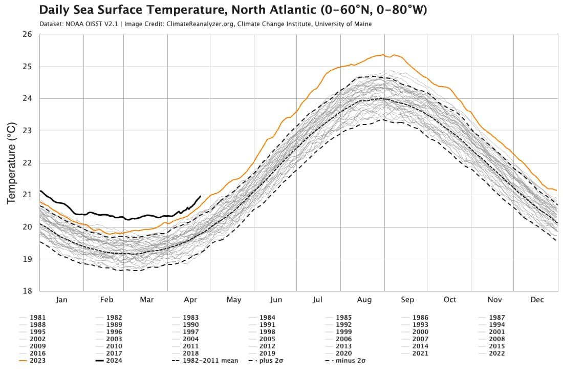
If you prefer SST anomalies, then the University of Maine’s web page is helpful for that. The latest SST chart can be seen below, again showing how Atlantic temperatures are running ahead of trends.
Given how warm the Atlantic currently is, it’s perhaps no surprise there is the potential for the first tropical disturbance of the year to be warned at this stage in April.
But, if these temperatures continue at such levels and the other conditions, such as wind shear and the expected shift to La Nina, all happen on cue, then we could be in for a long season with numerous tropical storms and hurricanes, fulfilling what almost all of the forecasts are calling for.
Track the 2024 Atlantic tropical storm and hurricane season on our dedicated page and we’ll update you as new information emerges.